Neueste | Meistgesehene
Neueste | Meistgelesene


E6 Voio, das atemberaubende Bergmassiv im Regionalbezirk Kozani

  232 Wörter 1 Minute 974 × gelesen
2017-04-30 2017-04-30 30.04.2017

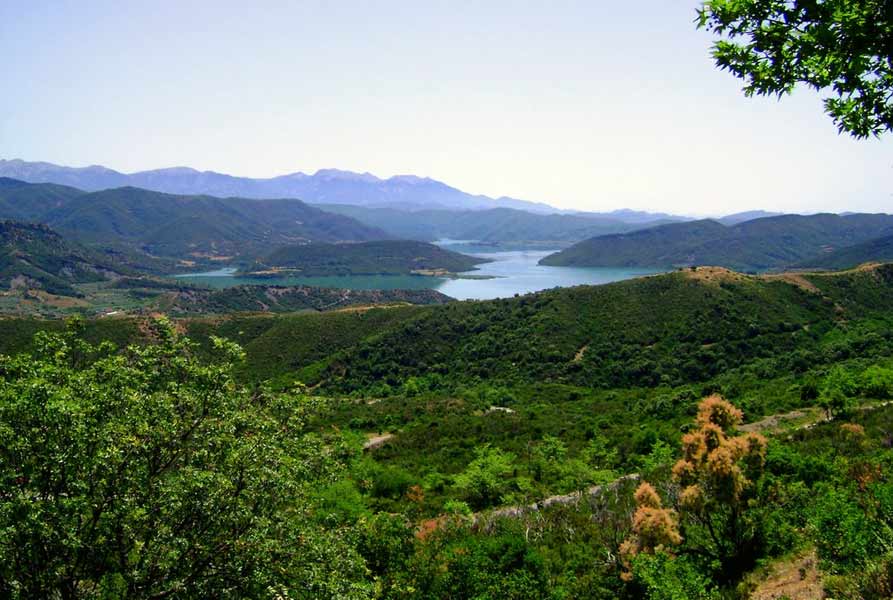
An der Grenze zwischen Epirus und dem westlichen Makedonien beginnt eine atemberaubende Strecke des europäischen Wanderpfades E6 am Bergmassiv Voio. Am nördlichen Fuße des Pindos-Gebirges, zwischen den Bergmassiven Grammos und Smolikas, befindet sich das Bergmassiv Voio, wo die Ursprünge des Flusses Aliakmonas liegen. Voio ist einer der waldreichsten Berge Griechenlands. Der Anteil der Waldfläche beträgt rund 80% der Gesamtfläche und bietet Lebensraum für zahlreiche seltene und bedrohte Tier- und Pflanzenarten. An seiner nordöstlichen Spitze liegen die Gipfel „Große und kleine Ontria“, die eine beeindruckende, von hohen Felsen eingerahmte Hochebene bilden.

Ausgangspunkt einer der schönsten Routen des Wanderpfades E6 ist das Dorf Pentalofo auf 1060 Metern Höhe im südlichen Voio. Dies ist das größte Steindorf der Gegend und gehört zu den bekannten „Mastorochoria“, deren Bewohner sich seit Jahrhunderten mit der Steinbaukunst beschäftigen. Durch dichte Mischwälder von Eichen, Kastanien und Kiefern führt der Wanderweg zum Dorf Nea Kotyli, ein gut erhaltenes malerisches Dorf auf 1450 Metern Höhe.

Am östlichen Fuß des Bergmassivs Voio im Regionalbezirk Kozani liegt die Gemeinde Voio, deren Hauptstadt Siatista ist. Ab Mitte des 17. Jahrhunderts blühte in dieser Gegend der Leder- und Baumwollhandel, und bis Ende des 19. Jh. erfuhr die Stadt ein großes Wachstum. Heute ist Siatista für den Pelzhandel und für Weine hoher Qualität bekannt. Ferner können Besucher die wunderschönen neu restaurierten Herrenhäuser bewundern und die „Manouseia“ Bibliothek mit seltenen Büchern und Handschriften aus dem 16. Jahrhundert besuchen.

35 Bilder für das Keyword Pindos-Gebirge gefunden.

Der Berg Τomaros im Regionalbezirk Ioannina in Westgriechenland gehört zum Pindos-Gebirge und erhebt sich mit einer maximalen Höhe von 1.974 m südlich der historischen Stätte von Dodona. Mount Tomaros is a mountain in the southwestern regional unit of Ioannina with a maximum elevation of 1,974 m, it is part of the Pindus mountain range and located not far from the archaeological site of Dodona. Τόμαρος είναι βουνό του Νομού Ιωαννίνων με υψηλότερη κορυφή τον Πεντόλακο, 1.974 μέτρα, βρίσκεται νοτιοδυτικά της πόλης των Ιωαννίνων και κοντά στο αρχαίο μαντείο της Δωδώνης. Dimitrios Pergialis
Kostas Krystallis (1868-1894), griechischer Dichter und Schriftsteller der Neuen Athener Schule – Sirako ist ein malerisches Bergdorf der Gemeinde Voria Tzoumerka, es liegt an den Hängen des Berges Lakmos im Pindos-Gebirge in der griechischen Region Epirus. Kostas Krystallis (1868-1894), a Greek author and poet of the New Athenian school – Syrrako is a mountain village of the municipality North Tzoumerka on the slopes of Mount Lakmos in the Pindus mountains in the Greek region of Epirus. Κώστας Κρυστάλλης (1868-1894) ήταν Έλληνας ποιητής και πεζογράφος της Νέας Αθηναϊκής σχολής - To Συρράκο είναι χωριό του νομού Ιωαννίνων, στον Δήμο Βορείων Τζουμέρκων, χτισμένο στην πλαγιά του όρους Λάκμος, σε υψόμετρο 1.150 μ. Vangelis Doutsios
Sirako ist ein malerisches Bergdorf der Gemeinde Voria Tzoumerka, es liegt an den Hängen des Berges Lakmos im Pindos-Gebirge in der griechischen Region Epirus. Syrrako is a mountain village of the municipality North Tzoumerka on the slopes of Mount Lakmos in the Pindus mountains in the Greek region of Epirus. To Συρράκο είναι χωριό του νομού Ιωαννίνων, στον Δήμο Βορείων Τζουμέρκων, χτισμένο στην πλαγιά του όρους Λάκμος, σε υψόμετρο 1.150 μ., και βρίσκεται πάνω από την χαράδρα του ποταμού Χρούσια. Vangelis Doutsios
Tzari Brücke - Der Arachthos ist der achtgrößte Fluss Griechenlands und einer der wichtigsten in der Region Epirus, mit einer Gesamtlänge von 135 km entspringt er im Pindos-Gebirge und fließt in den Ambrakischen Golf des Ionischen Meeres. Bridge of Tzari – The Arachthos River is the eighth largest river in Greece and one of the most important ones in the region of Epirus, the Arachthos River is 135 km long, has its source in the Pindus mountains and flows into the Ambracian Gulf. Γέφυρα Τζαρή - Ο Άραχθος είναι ο όγδοος μεγαλύτερος ποταμός της Ελλάδας, από τους κυριότερους ποταμούς της Ηπείρου με συνολικό μήκος 135 χιλιόμετρα. Vangelis Doutsios
Die neue Plaka Brücke - Der Arachthos ist der achtgrößte Fluss Griechenlands und einer der wichtigsten in der Region Epirus, mit einer Gesamtlänge von 135 km entspringt er im Pindos-Gebirge und fließt in den Ambrakischen Golf des Ionischen Meeres. New Bridge of Plaka – The Arachthos River is the eighth largest river in Greece and one of the most important ones in the region of Epirus, the Arachthos River is 135 km long, has its source in the Pindus mountains and flows into the Ambracian Gulf. Νέα γέφυρα της Πλάκας - Ο Άραχθος είναι ο όγδοος μεγαλύτερος ποταμός της Ελλάδας, από τους κυριότερους ποταμούς της Ηπείρου με συνολικό μήκος 135 χιλιόμετρα. Vangelis Doutsios
Plaka Brücke - Der Arachthos ist der achtgrößte Fluss Griechenlands und einer der wichtigsten in der Region Epirus, mit einer Gesamtlänge von 135 km entspringt er im Pindos-Gebirge und fließt in den Ambrakischen Golf des Ionischen Meeres. Bridge of Plaka – The Arachthos River is the eighth largest river in Greece and one of the most important ones in the region of Epirus, the Arachthos River is 135 km long, has its source in the Pindus mountains and flows into the Ambracian Gulf. Γέφυρα της Πλάκας - Ο Άραχθος είναι ο όγδοος μεγαλύτερος ποταμός της Ελλάδας, από τους κυριότερους ποταμούς της Ηπείρου με συνολικό μήκος 135 χιλιόμετρα. Vangelis Doutsios
Der Arachthos ist der achtgrößte Fluss Griechenlands und einer der wichtigsten in der Region Epirus, mit einer Gesamtlänge von 135 km entspringt er im Pindos-Gebirge und fließt in den Ambrakischen Golf des Ionischen Meeres. The Arachthos River is the eighth largest river in Greece and one of the most important ones in the region of Epirus, the Arachthos River is 135 km long, has its source in the Pindus mountains and flows into the Ambracian Gulf of the Ionian Sea. Ο Άραχθος είναι ο όγδοος μεγαλύτερος ποταμός της Ελλάδας, από τους κυριότερους ποταμούς της Ηπείρου με συνολικό μήκος 135 χιλιόμετρα. Vangelis Doutsios